12 Spectacular Spots for Fall Colors
Blue Ridge has so many spots to enjoy the splendor of fall colors. Here are a dozen special places to experience the beauty…

Lake Blue Ridge Recreation Day Use Area
Here’s a quiet spot with great paved walkways that make for easy strolls and biking. Open every day, the trails wind close to Lake Blue Ridge through thick mixed hardwood forest. It’s right off Aska Road. Please be careful if biking here in the middle of leaf season after a rain… fallen leaves can be slick on the pavement. Download free map here.
Aska Road
This scenic, twisting two-lane road through farms, nature and wilderness in Fannin County makes for a leisurely drive south from Blue Ridge. There are many stops along the way and many jaw dropping forest scenes and farm scapes painted in fall colors.

Three Forks Area
For those with a 4-wheel drive vehicle, this area of the Chattahoochee National Forest has it all. The drive along Noontootla Creek has tumbling waters, lush forested mountainsides and access to some of the prime natural attractions in the whole southeastern USA… the start of the famous Appalachian Trail on Springer Mountain, the Chattahoochee National Fish Hatchery and Long Creek Falls, just to name a few. Download free map here.
Springer Mountain and the AT
From Three Forks you can begin a 3 mile uphill hike to the beginning of the 2,200 mile long Appalachian Trail. For a less strenuous experience, it’s possible to drive past Three Forks to the parking lot at Springer Mountain and hike a short trail to the terminus. The views, in a word, are breathtaking. Download free map here.


The Folk Collaborative
A one-of-a-kind authentic Appalachian experience near McCaysville, The Folk Collaborative offers a small step back in time. Bonfires, local music, wildflower fields, fruit orchards, wagon rides, farm tours, picnics, U-pick, festivals, outdoor movies, yoga, workshops and classes await you throughout the year.
Luke, the local herbalist, creates tinctures, essential oils and herb bundles from locally grown Appalachian bounty and his grandma’s traditions.

Mercier Orchards
Mercier Orchards the largest apple orchard in the southeast, is known as Southern Living Magazine's "favorite roadside apple market," but it is much, much more. For over 75 years, the Mercier family has been welcoming visitors to taste the fruits of the mountains, and the yummy fried pies, apple cider, apple butter and fritters that come from the fruit!
Enjoy u-pick apples, live music and food vendors each weekend through October. Peruse the market to purchase bulk apples, the best pies, all kinds of cute souvenirs and more. Locals tip: the bakery alone is worth the trip!
Brasstown Bald
The highest mountain in Georgia at 4,784 feet above sea level, is one of the most magnificent places to experience 360 degree views of the surrounding Blue Ridge Mountains. In fall the colors sweep out in vistas literally hundreds of miles across. You reach the summit by driving up the mountain in a twisty paved access road, then you can hike from the huge parking lot to the summit and visitor center deck, or in season, take a shuttle. The trip to Brasstown Bald is a real memory maker, to be experienced in solitude or shared with loved ones. Download free map here.

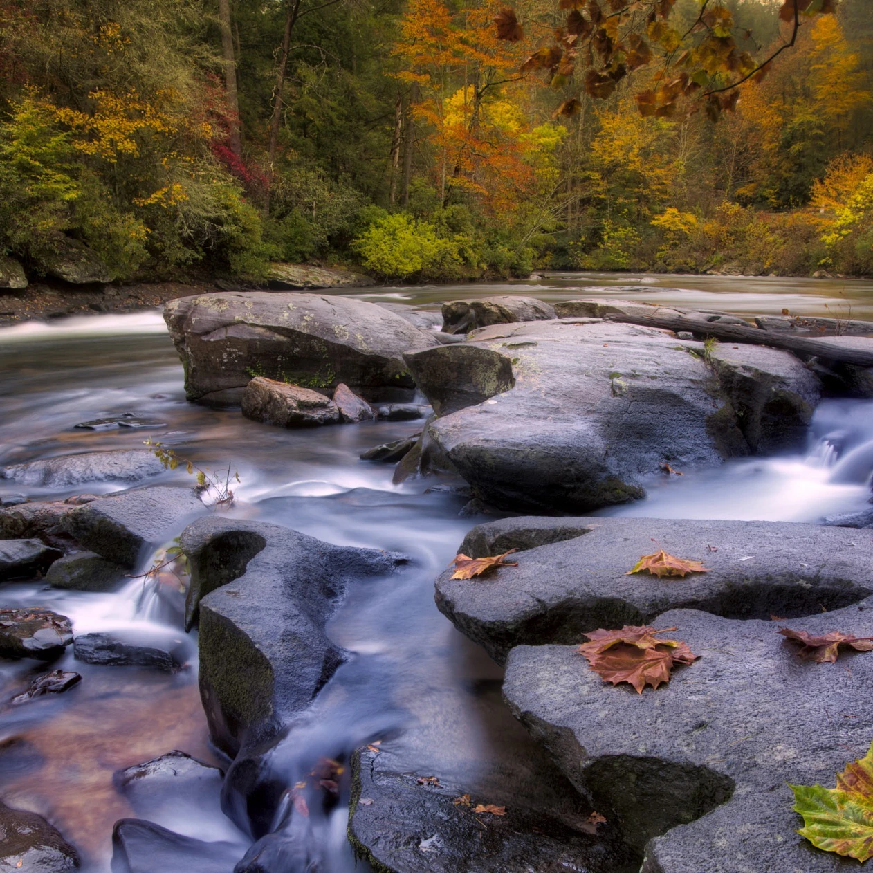
Toccoa River Rapids
About halfway down Aska Road a pull-off along the Toccoa River provides a scenic rush of whitewater, and in fall, drifting colorful leaves on one of north Georgia’s most scenic rivers. You can take a picnic and sit on the rocks along the river, almost in the middle of the rapids.

Blue Ridge Scenic Railway
Always a crowd pleaser for families and couples alike, The Blue Ridge Scenic Railway offers fall leaf viewing trips. The route north follows the Toccoa River and winds through pristine farmland until it reaches McCaysville, GA and Copper Hill, TN for a lunch and strolling stop before heading back to the Depot in Blue Ridge. Be sure to check out their new railbikes for a great way to check out the fall colors and enjoy the fall weather.
Ada Street to Curtis Switch
From downtown Blue Ridge, the start of Ada Street winds through scenic countryside views all the way out to another section of the Toccoa River at Curtis Switch. Along the way looking west, you can see over Mercier Orchards rolling apple orchard, and in the distance the ridges of the Cohutta Wilderness. Curtis Switch has a small canoe boat launch that makes for a nice perch to dip your toes in the chilly water and watch fall leaves drift like little boats in the current of the Toccoa River. Or at the right time of day see the Blue Ridge Scenic Railway train pass by on the other side of the river.

More to Explore

Fall Colors With a Twist
There are so many ways to experience fall in the North Georgia Mountains. Here are some unusual experiences that make…

Fall Fishing with Cohutta Fishing Company
Fall is around the corner. No season brings us more excitement to be in the North Georgia Mountains and Blue…
Take a scenic drive through gorgeous North Georgia Mountain scenery
These scenic drives in Georgia's Blue Ridge combine some of the prettiest views of the countryside with curvy mountain roads…

Top 20 Things to Do in Blue Ridge GA
Here are some great ways to make the most of your visit from mountain views, to parks, to family adventure…

Where To Find Cool in Blue Ridge, Georgia
Jump into a cool wilderness water spot. Hear some live music with drinks and great food in town. Do some…
